Why Drone Photography is Revolutionizing Real Estate Marketing
Drone photography for realtors has become a game-changer in how properties are marketed and sold. With 97% of homebuyers starting their property search online, the quality of your listing photos can make or break a sale.
Quick Answer for Realtors:
– What it is: Using unmanned aircraft with high-resolution cameras to capture aerial property photos and videos
– Key benefits: Homes sell 68% faster, 65% more likely to get showings, 83% of sellers prefer agents who use drones
– Requirements: FAA Part 107 license for commercial use, drone registration, insurance coverage
– Cost: $100-$500 for professional services, $200-$2,500 to buy your own equipment
– Best for: Large properties, waterfront homes, luxury estates, new construction
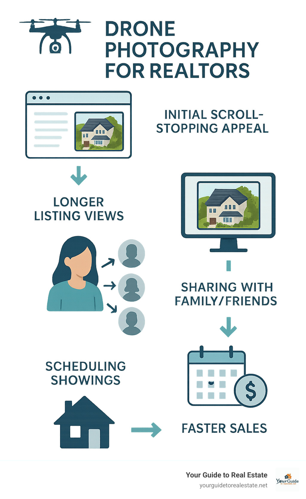
The numbers tell the story. Properties with aerial photos don’t just look better – they perform better. Buyers are 65% more likely to schedule in-person showings when listings include drone imagery. And here’s the kicker: 83% of home sellers now prefer working with agents who offer drone photography.
This isn’t just about pretty pictures. It’s about giving potential buyers the full story of a property – the neighborhood context, the outdoor spaces, the relationship to nearby amenities. Traditional ground-level photos can’t capture what a sweeping aerial view reveals in seconds.
Quick drone photography for realtors terms:
– virtual real estate assistant
– virtual real estate brokerage
– virtual reality home tours
Drone Photography for Realtors: Definitions, Benefits & Impact
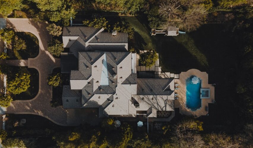
Drone photography for realtors uses unmanned aircraft equipped with professional-grade cameras to capture aerial imaging. These sophisticated devices capture stunning 4K footage and crystal-clear photos from perspectives that were once only possible with expensive helicopters.
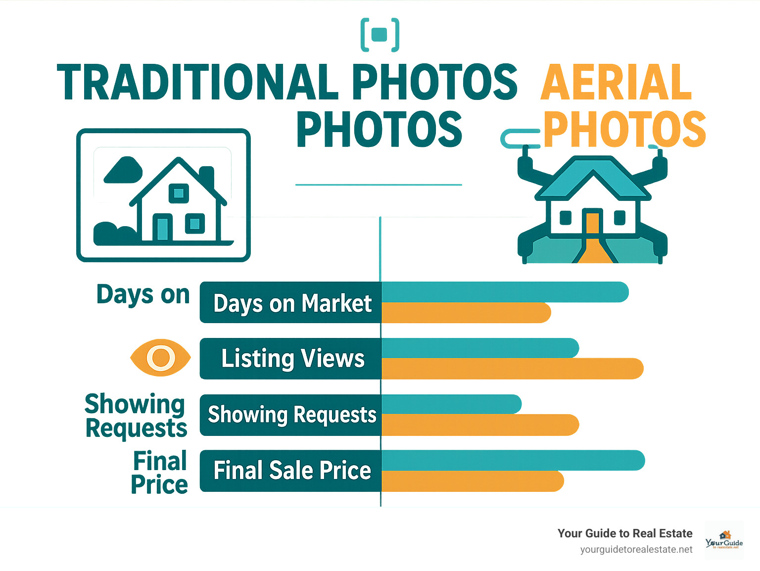
The numbers are impressive. Properties featuring aerial photography sell 68% faster than those relying solely on traditional ground-level shots. That’s the difference between a listing that lingers for months and one that moves in weeks.
Buyers are 65% more likely to schedule showings when they see aerial imagery in listings. When you can see the full property layout, understand how the house sits on the lot, and get a real sense of the neighborhood context, you’re much more confident about investing your time in a visit.
83% of sellers now prefer working with agents who offer drone photography. It’s become an expectation rather than a nice-to-have.

The aerial perspective provides neighborhood context that ground photography cannot. According to research on digital-age buyers from the National Association of Realtors, today’s buyers spend over 60% of their time examining property photos online before making decisions about showings.
How It Works & When to Use It
Modern camera drones feature high-resolution sensors (often 20+ megapixels), sophisticated gimbal stability systems, and GPS-guided flight controls. The gimbal keeps your camera rock-steady even when the wind picks up, ensuring smooth, professional footage.
Timing matters enormously. The golden hour – just after sunrise or before sunset – transforms ordinary properties into cinematic masterpieces with soft, warm light that eliminates harsh shadows.
Top Property Types That Shine
Luxury estates are natural candidates, where aerial shots showcase extensive grounds, pools, tennis courts, and guest houses in one comprehensive view.
Rural acreage properties practically demand aerial photography. Buyers need to understand the full scope of the land and its topography.
Waterfront properties excel with drone photography, showcasing dock access, beach frontage, and water views that ground photography cannot capture.
Construction lots benefit from the aerial perspective, helping buyers visualize how the lot sits in relation to the neighborhood.
Marketing Metrics That Matter
Click-through rates from listing portals increase dramatically when aerial photos serve as the lead image. Days on market consistently decrease for properties featuring drone imagery. Listing views and engagement metrics show substantial improvements across the board.
Regulations, Safety & Privacy Essentials
When it comes to drone photography for realtors, the rules aren’t optional. The FAA takes commercial drone operations seriously, and taking photos for real estate listings absolutely counts as commercial use.
The cornerstone requirement is your FAA Part 107 certification. You’ll need to pass a comprehensive aeronautical knowledge test covering airspace classification, weather patterns, flight operations, and safety procedures. Plan on 2-3 weeks of study time.
Every drone used for commercial purposes must be registered with the FAA. It costs $5 and lasts for three years. You’ll need to display that registration number on the outside of your drone.
The Remote Identification Rule requires your drone to broadcast a digital ID during flight. Most newer drones have this built in, but older models might need an add-on module.
Altitude restrictions are strictly enforced at 400 feet above ground level. There’s also a 100 mph speed limit. Local no-fly zones can pop up anywhere – military bases, airports, national parks, and temporary restrictions for events.
Privacy considerations fall under NTIA voluntary best practices. Always notify neighbors about planned flights and be mindful of capturing adjacent properties.
Your insurance coverage needs to explicitly include drone operations. Many standard business policies exclude unmanned aircraft.
For complete certification requirements, the FAA’s official Part 107 guidance walks you through everything step by step.
Step-by-Step Compliance Checklist
Start by studying for the aeronautical knowledge test – most people need 2-3 weeks of consistent study time. Take the actual test at an FAA-approved testing center ($150, need 70% to pass).
Once you pass, submit FAA Form 8710-13 for your remote pilot certificate application. The TSA background check happens automatically. After approval, you’ll receive your remote pilot certificate (valid 24 months) and separately register your drone (valid 36 months).
Renewal schedules – remote pilot certificates need renewing every 24 months, drone registration every 36 months.
Safety & Neighbor Relations
Maintain visual line of sight with your drone at all times – this is both an FAA requirement and common sense.
Flight planning apps like B4UFLY or AirMap should be part of your pre-flight routine every time. These show no-fly zones and temporary flight restrictions.
Neighbor relations matter. Taking five minutes to let neighbors know you’ll be flying for professional photography can prevent complaints and build goodwill. Some agents put up small courtesy signs during shoots.
Every flight reflects on your professionalism and the real estate industry as a whole.
Budgets, Gear & Hiring the Right Pilot
When it comes to drone photography for realtors, you’ve got two main options: hire a pro or do it yourself.
Professional drone services typically run $100-$500 per property shoot. Basic aerial photo packages might cost $100-$200, while full video packages with professional editing can reach $300-$500 or higher.
For the DIY route, entry-level drones that produce decent real estate shots start around $200-$500. Mid-range prosumer drones ($500-$1,500) offer proper 4K video, 20-30 minutes flight time, obstacle avoidance, and professional camera quality. High-end professional drones run $1,500-$10,000+ for features like swappable lenses and 6K-8K video.
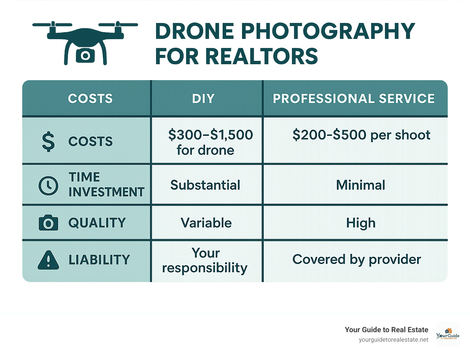
Going DIY isn’t just about buying the drone. Factor in Part 107 certification, insurance, learning time, and inevitable crashes while getting the hang of it. Most agents find that unless they’re shooting dozens of properties, hiring a professional makes more financial sense.
Must-Have Equipment Features
3-axis gimbal stabilization isn’t negotiable – it’s the difference between smooth, cinematic footage and shaky amateur video.
RAW photo capture provides editing flexibility for exposure adjustments, color correction, and sky replacement.
25+ minute flight time keeps you efficient. Professional shoots need multiple angles and several takes.
ND filters prevent overexposure in bright daylight while maintaining smooth, cinematic video quality.
Obstacle avoidance sensors can save you from expensive crashes around trees, power lines, and roof edges.
What to Ask Before You Book
“Do you have a current Part 107 license?” should get an immediate yes. Ask to see the certificate if there’s hesitation.
“Are you insured for commercial operations?” General liability insurance that covers real estate photography protects both parties.
“What’s your typical turnaround time?” Most pros deliver edited photos within 24-48 hours. Video takes 3-5 business days.
“What exactly will I receive?” prevents misunderstandings. Understand usage rights – you want to use content across all marketing channels without restrictions.
The best pilots have portfolios ready, clear pricing structures, and professional communication from first contact.
For more insights on property photography, check out our guide on home photography tips.
Shooting & Marketing: Pro Tips That Sell Homes Faster
Great drone photography for realtors starts with solid pre-flight planning. Scout the property first to spot the best angles, identify obstacles like power lines, and map out your flight path.
Think of your drone shoot like directing a mini movie. Your shot list becomes your script.
The approach shot shows how buyers would arrive at the property. The overhead nadir view reveals the complete property layout like a living blueprint. Orbit maneuvers create that cinematic look – the aircraft flies in a smooth circle around the property while keeping the camera locked on the house.
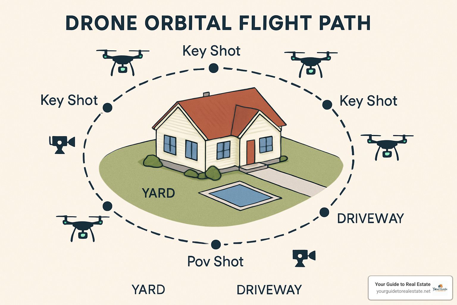
Neighborhood context shots show nearby parks, schools, or shopping centers. Feature highlight shots of pools, gardens, or unique architectural details turn browsers into buyers.
Top-down nadir shots work especially well for properties with pools, extensive landscaping, or multiple buildings, showing relationships between structures that ground photos can’t capture.
The editing workflow transforms good footage into marketing gold. Professional editing often includes sky replacement, color grading, and exposure correction to ensure every shot looks magazine-ready.
Your social media rollout strategy matters. Aerial photos and videos consistently outperform traditional listing photos on Instagram, Facebook, and YouTube.
Integrating Aerials with Other Tech
3D virtual tours that begin with aerial approach and transition into interior walkthroughs create immersive experiences. Interactive floor plans become more meaningful when paired with aerial context shots.
For cutting-edge virtual tour strategies, check out our guide to Virtual Reality Home Tours.
Overcoming Common Challenges
Wind limits aren’t suggestions – they’re safety requirements. Most consumer drones struggle in winds over 15-20 mph.
Glare control separates pros from amateurs. Golden hour shoots help, but you also need to understand polarizing filters and camera angles.
Battery management becomes critical during complex shoots. Plan shots to maximize each battery cycle and always carry spares.
Post-rain reflections present opportunities if you know how to work with them, creating stunning reflections that add drama.
Frequently Asked Questions about Drone Photography for Realtors
Why is drone photography for realtors so effective?
The magic of drone photography for realtors lies in its scroll-stopping power. When buyers click through listings, a stunning aerial view catches their eye and stops the scroll.
Ground-level photos show a house, but aerial shots reveal a lifestyle. They answer questions buyers didn’t know they had: How private is the backyard? What’s the neighborhood like? How does this property relate to mentioned amenities?
The emotional impact runs deeper than pretty pictures. Sweeping aerial views help buyers imagine their future lifestyle – Saturday morning coffee on the deck or hosting summer barbecues with incredible backdrops.
Do realtors need a license for drone photography for realtors?
Yes, you absolutely need proper certification for commercial flying. The FAA doesn’t care if you’re helping sell a house – if you’re using a drone for business purposes, you need that FAA Part 107 Remote Pilot Certificate.
The certification requires studying aeronautical knowledge, passing a written exam (70% minimum), and completing a TSA background check. The process takes a few weeks and certificates last 24 months.
Many successful agents never get certified themselves – they hire licensed drone pilots instead. This often makes more financial sense when factoring in equipment costs, insurance, and time investment.
How many aerial photos should a listing include?
Research shows 57% of buyers now expect at least 8-10 aerial shots for residential properties. Each aerial photo tells a different story – property approach, overhead layout, neighborhood context, and outdoor spaces.
The key isn’t hitting a magic number – it’s about variety and storytelling. Each image should reveal something new and valuable about the property. Unique features like pools, tennis courts, or waterfront access deserve dedicated aerial spotlight shots.
Conclusion
The numbers don’t lie – drone photography for realtors has moved from “nice to have” to “must have” in today’s competitive market. When your listings sell 68% faster and buyers are 65% more likely to schedule showings, you’re driving real business results.
The future looks exciting. AR integration where buyers can point phones at aerial footage for instant property information overlays is happening now. 3D mapping technology will seamlessly blend aerial photography with interior virtual tours.
Technology differentiation matters. When buyers have endless options and sellers are choosier than ever, using cutting-edge tools like drone photography signals you’re serious about results. Your clients notice when you deliver marketing materials that look magazine-quality.
The real estate industry changes fast, and staying current isn’t optional. Technology adoption separates successful agents from those who struggle. For insights into what’s coming next, our guide on how technology is revolutionizing real estate 2025 trends to watch covers innovations shaping our industry.
Whether you get your Part 107 certification or partner with professional drone pilots, the key is to start. Your first aerial shoot will surprise you – not just with photo quality, but with how buyers and sellers react.
At YourGuideToRealEstate.net, we’ve watched countless agents transform their marketing with drone photography. Those who adopt it early don’t just get better listings – they get more of them. When sellers see what you can do with their neighbor’s property, they want that same service.
Your listings deserve to stand out. Your clients deserve cutting-edge marketing. And you deserve the competitive advantage that comes with offering something most agents still don’t. The sky’s the limit – literally.


")